Beiträge von Mouchi

Willkommen in der Transport Fever Community

Wir begrüßen euch in der Fan-Community zu den Spielen Transport Fever und Train Fever, den Wirtschaftssimulatoren von Urban Games. Die Community steht euch kostenlos zur Verfügung damit ihr euch über das Spiel austauschen und informieren könnt. Wir pflegen hier einen freundlichen und sachlichen Umgang untereinander und unser Team steht euch in allen Fragen gerne beiseite.


Die Registrierung und Nutzung ist selbstverständlich kostenlos.


Wir wünschen euch viel Spaß und hoffen auf rege Beteiligung.

Das Team der Transport-Fever Community


    Do you mean the water level? This is already shown with blue.If you mean a line every 100m as reference, then I can implement this :)

    Yes I thought to the water level. For example, if you know what is the grey value you want for the water level, you can change the highest point until you reach this value. It is in addition to the blue you set. I agree it is not a high necessary feature ;)


    A line at every 100m (or another frequency depending to highest/lowest points) can be interesting. But I think, it will be better with a checkbox to add/remove these lines in order to set more easily the towns for example.

    Until four hours ago, it really was 0 = lowest and 255 = highest ;) I changed this just today:


    Translates to: I removed the auto-level (which actually expands the image range to 0-255, if not the case) from the tool, as I suspected it to cause the steps in the map.


    So, the lower number corresponds to black and the higher number to white.
    But, I will now change this back to the behavior I originally released this tool with:
    That the lower number really corresponds to the lowest point on the map and respectively for the higher number to the highest points.

    Entschuldigung. I have not tested again before to post. Thanks for fixing.


    I thank you so much for this tool. With it, I have successed to understand how the range works, and I can set cities on a map whereas I have not understand how the position works.
    The maps I have created won't exist without you.


    I agree with your TODO list, especially "Catch possible errors" which can avoid to launch the games many times to have only an error.


    I have 2 suggestions, faster to code in order to not take many of your time:


    • Display the gray value corresponding to the 100m altitude. It is easy to compute and useful to adjust the map pixel by pixel.
    • Allow to set the cities (and later industries) by the pixel coordinates. It is a temporary solution before you implement zoom to have a precise position. I have set many cities in the water instead of near it. With this, there will be no problems.

    Leider nein, in beiden Fällen. ;( Übrigens, irgendetwas haut bei der Wasserlevelvorschau nicht ganz hin.
    Das(ein paar Seen mit Fluss)zeigt mir Dein Tool an.


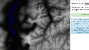
    Und das( Mecklenburger Seenplatte im Kaukasus) zeigt mir das Spiel.

    Sorry I am not a German speaker.
    I have also observed that.
    I think there is a bug with the range computation.


    Let y the altitude of point on the map, x the grey value in the height map.
    Assume that the relationship is linear between this 2 variables: y = a*x + b.
    So the range value give to the game the 2 equation to solve a linear system to have the a and b values.
    The problem is to know to what x values correspond the values given by the range.
    I think the bug is here.
    The first value is not for the lower point but for x = 0 (and not 10 with your map transformation).
    By the same way, the 2nd value is not for the highest point but for x = 255.


    To compute the good values of the range, I have fixed the value for x = 0 to 0 (sometimes I have increased it to have lower mountains).
    Then I choose the grey value for the water limit. In mathematics word, the x value for which y will be equal to 0.
    So I have 2 equations, the system is solvable.
    So I have the a and b values. So the 2nd value for the range is equal to 255*a + b.
    It works well.